


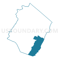
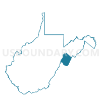
Voting District 11, Pendleton County, West Virginia
About
Outline

Summary
| Unique Area Identifier | 691667 |
| Name | Voting District 11 |
| County | Pendleton County |
| State | West Virginia |
| Area (square miles) | 75.73 |
| Land Area (square miles) | 75.49 |
| Water Area (square miles) | 0.24 |
| % of Land Area | 99.68 |
| % of Water Area | 0.32 |
| Latitude of the Internal Point | 38.55233140 |
| Longtitude of the Internal Point | -79.22660880 |
Maps

Graphs
Select a template below for downloading or customizing gragh for Voting District 11, Pendleton County, West Virginia


Neighbors
Neighoring Voting District (by Name) Neighboring Voting District on the Map
- Voting District 12, Pendleton County, WV
- Voting District 2, Pendleton County, WV
- Voting District 5, Pendleton County, WV
- Voting District 6, Pendleton County, WV
- Headwaters Voting District, Highland County, VA
- Mount Solon Voting District, Augusta County, VA
- Mt. Clinton Voting District, Rockingham County, VA
- Ottobine Voting District, Rockingham County, VA
Top 10 Neighboring County Subdivision (by Population) Neighboring County Subdivision on the Map
- Ashby district, Rockingham County, VA (21,326)
- Central district, Rockingham County, VA (12,774)
- North River district, Augusta County, VA (9,227)
- Central district, Pendleton County, WV (2,665)
- Eastern district, Pendleton County, WV (2,464)
- Stonewall district, Highland County, VA (684)
Top 10 Neighboring Place (by Population) Neighboring Place on the Map
Top 10 Neighboring Unified School District (by Population) Neighboring Unified School District on the Map
- Rockingham County Public Schools, VA (76,314)
- Augusta County Public Schools, VA (73,750)
- Pendleton County School District, WV (7,695)
- Highland County Public Schools, VA (2,321)
Top 10 Neighboring State Legislative District Lower Chamber (by Population) Neighboring State Legislative District Lower Chamber on the Map
- State House District 26, VA (82,704)
- State House District 20, VA (76,800)
- State House District 47, WV (19,933)
Top 10 Neighboring State Legislative District Upper Chamber (by Population) Neighboring State Legislative District Upper Chamber on the Map
- State Senate District 26, VA (201,456)
- State Senate District 24, VA (200,978)
- State Senate District 15, WV (122,121)
Top 10 Neighboring 111th Congressional District (by Population) Neighboring 111th Congressional District on the Map
Top 10 Neighboring Census Tract (by Population) Neighboring Census Tract on the Map
- Census Tract 112, Rockingham County, VA (4,929)
- Census Tract 9705, Pendleton County, WV (3,775)
- Census Tract 702, Augusta County, VA (3,754)
- Census Tract 111, Rockingham County, VA (3,183)
- Census Tract 9701, Highland County, VA (2,321)
- Census Tract 9706, Pendleton County, WV (2,134)
Top 10 Neighboring 5-Digit ZIP Code Tabulation Area (by Population) Neighboring 5-Digit ZIP Code Tabulation Area on the Map
- 22821, VA (5,753)
- 26807, WV (2,947)
- 22843, VA (2,458)
- 26802, WV (1,357)
- 22831, VA (813)
- 26815, WV (646)
- 24442, VA (120)